You stand at the edge of your lawn, a cold iced tea sweating in your hand, looking at a wooden stake your neighbor just pounded into the dirt. According to the glossy real estate app on your phone, your yard extends another three feet past that stake. The satellite overlay shows a neat, glowing blue line slicing right through their new flower bed, confirming your suspicions.
It feels like a victory of modern technology, but you are looking at the illusion of digital precision.
When tempers flare over fences and felled trees, we instinctively reach for our phones or pull up the county mapping website. We assume that a satellite orbiting in space, beaming down coordinates to the inch, holds the ultimate truth of what we own. The map feels indisputable, mathematically pure, and legally binding.
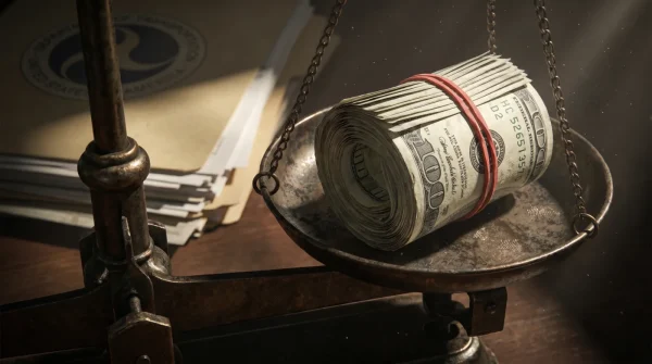
But American property law cares very little about your screen, choosing instead the authority of buried iron. This is the quiet, often frustrating reality of land ownership: modern GPS surveys frequently contradict original county plat maps, and when they do, the court system almost universally sides with a rusting piece of metal slammed into the earth half a century ago.
The Ghosts in the Soil
The legal doctrine governing our backyards is entirely rooted in history rather than geometry. It is based on the concept of ‘original intent.’ When a plot of land was first carved out of a larger tract, a surveyor walked the physical ground, took measurements, and drove a monument into the soil. That original physical act created the boundary.
It traces back to early frontier law, prioritizing original intent over modern math. Even if that surveyor’s measuring chain was stretched, even if his compass was affected by local iron ore, and even if his math was objectively wrong by today’s satellite standards, the monument he placed dictates the legal property line.
Imagine a surveyor in 1965 marking a one-acre lot. He drives an iron pin into the corner. Over the decades, GPS technology evolves, proving the pin was actually placed four feet too far to the west. If you buy that lot today, you own the land up to the pin, not up to the mathematically perfect coordinate.
Because that physical marker was accepted by the original owners, the physical anchor holds legal weight. Arguing against a physical fifty-year-old monument using a modern smartphone app is like breathing through a pillow—exhausting, stifling, and legally futile.
Meet Arthur Vance, a 62-year-old land surveyor working the rolling hills of Ohio. Last November, Arthur spent three hours digging through frozen clay in a suburban backyard. The homeowner had hired him to prove a neighbor’s shed was encroaching on their lot, armed with printouts of glowing satellite maps. Arthur barely glanced at the paper.
Instead, he swept a magnetic locator over a patch of dying ivy until it screamed, then dug down two feet to unearth a rusted axle from a Ford. The original surveyor in 1948 had simply used whatever scrap metal was in his truck to mark the corner. That rusted axle, Arthur explained to the devastated homeowner, was the undeniable legal boundary. The GPS was off by four feet, but the court would not care.
Adjusting for Your Topography
Depending on when and where your house was built, the ‘monuments’ guarding your property line will look vastly different. Understanding your specific terrain is the first step in avoiding a costly legal battle over a strip of grass.
For the Historic Homeowner
In neighborhoods built before the 1920s, you are often dealing with competing deeds and vague descriptions. Your property line might be defined by a ‘large oak tree’ that died forty years ago, or an old stone wall that has long since crumbled. In these cases, surveyors look for secondary evidence of possession—where an old fence line used to run, or where the soil composition changes from decades of separate lawn care.
For the Suburban Subdivision Dweller
If your home was built in a planned tract after 1970, your corners are likely marked by standard iron rebars, often capped with a piece of colored plastic bearing the original surveyor’s license number. These are easier to find with a metal detector, but they are frequently buried under years of topsoil, mulch, and landscaping fabric.
For the Rural Homesteader
Out past the city limits, you are likely governed by ‘metes and bounds’ descriptions referencing stone walls and old oaks. You might find your corners marked by concrete columns, piles of rocks, or even old gun barrels driven into the dirt. Out here, physical possession and historical fence lines often carry more weight than any digital county map.
Mapping the Invisible Lines
Finding your true property line is not about proving someone wrong; it is about uncovering the historical agreement hidden in your soil. You can perform a preliminary check yourself before bringing in a professional.
Before you rent heavy equipment or draft a harsh letter, take a minimalist approach to property boundaries.
- Locate your original property deed and look for mentions of ‘iron pins,’ ‘monuments,’ or ‘rebars.’
- Rent or borrow a magnetic locator (not a standard coin metal detector, which won’t read deep enough).
- Measure the approximate distance from your house foundation as noted on the plat map.
- Sweep the locator in a three-foot radius around the suspected corner until you get a solid signal.
- Carefully probe the soil with a fiberglass rod before digging a small test hole to visually confirm the pin.
Tactical Toolkit: You will need a magnetic locator (Schonstedt is the industry standard), a 100-foot fiberglass measuring tape, a probing rod, and a hand trowel. Never use a backhoe or heavy shovel, as you risk bending or moving the monument, which legally compromises it.
Avoid the temptation to yank out a pin if it doesn’t favor you. A proper boundary negotiation requires a delicate touch. When discussing boundaries with a neighbor, the conversation should feel soft but structured, much like a perfect dessert where the cream should tremble just slightly at the edges—firm enough to hold its shape, but yielding enough to avoid a bitter break. Rushing to court is a fast track to escalating a quiet neighborhood dispute.
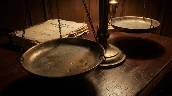
The Weight of the Soil
There is a strange comfort in realizing that our property lines are not dictated by cold algorithms in the cloud, but by the physical actions of people who stood exactly where we stand, decades ago. The law favors the tangible over the theoretical.
We want to believe that ownership is absolute, defined by neat lines and geometric perfection. But the reality teaches us that we are merely stewards of a physical space. We inherit the imperfections, the miscalculations, and the rusted iron left behind by those who came before us.
That rusted pipe buried under your hydrangeas is not just a marker; it is an enduring contract. Understanding its quiet authority will save you thousands in legal fees, preserve your relationship with the people next door, and give you a grounded, profound sense of exactly where your small piece of the earth truly begins.
‘A boundary is not a perfect line drawn on paper; it is a mutual agreement written in iron and buried in the earth itself.’
| Key Point | Detail | Added Value for the Reader |
|---|---|---|
| The Original Monument Doctrine | Physical markers placed by the first surveyor legally override modern GPS coordinates. | Saves you from hiring a lawyer based on misleading satellite app data. |
| Tool Selection | Standard metal detectors fail to find deep property pins; magnetic locators are required. | Prevents frustration and wasted time when trying to locate your own corners. |
| Historical Topography | Rural and historic boundaries often rely on physical possession and natural markers. | Helps you understand why old fence lines are incredibly difficult to challenge in court. |
Frequently Asked Boundary Questions
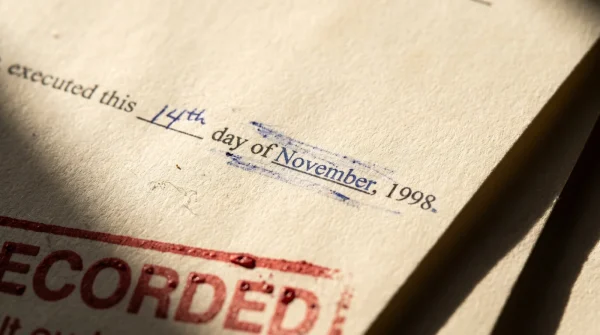
What if I accidentally dig up and move my property pin? Put it back as close to the original spot as possible, but legally, a disturbed monument loses its absolute authority. You may need a surveyor to reset it.
Can I use my county’s online GIS map to build a fence? No. County GIS maps explicitly state they are for tax assessment purposes only, not for determining legal property boundaries.
What if my neighbor and I can’t find any iron pins? If all original monuments are lost, a professional surveyor must be hired to recreate the boundary using adjacent property markers and historical deeds.
Does a fence that has been there for 20 years become the new property line? In many states, yes. Through a doctrine called ‘adverse possession’ or ‘boundary by agreement,’ a long-standing physical boundary can legally overwrite the deed.
Why do surveyors charge so much just to find four pins? You aren’t paying for the time it takes to dig; you are paying for their legal liability and the historical research required to verify those pins are the authentic original markers.